This initial field program focused on gathering ecological and topographic data at Raviravi in the Ba Province, Western Division. The team surveyed land elevations and mapped mangrove extent to better understand current site conditions.
These measurements will help determine the scale and feasibility of restoration, identify priority areas, and clarify what additional information is needed to guide future design.
Landscapes divided by levees
During the mid to late 20th century, many of Fiji’s coastal floodplains were drained to support agriculture. Tidal barriers and levees were built to exclude seawater, transforming intertidal wetlands into farmland.
Today, a clear contrast exists across these levees. On the seaward side, mangroves continue to thrive under natural tidal processes. On the landward side, the landscape is more mixed, some areas remain in use, while others have been abandoned.
A key question for Project Halo is why portions of this land are no longer farmed, and whether they could be suitable for tidal restoration. In many cases, abandonment appears linked to prolonged flooding, saltwater intrusion, and gradual land subsidence.
When drained soils are exposed to air over long periods, they can compact and oxidise, causing the ground surface to sink. As elevation decreases, drainage becomes less efficient and saltwater can increasingly encroach onto the land.
To better understand these subsidence dynamics, the team conducted detailed RTK GPS surveys during the field campaign, measuring precise elevation differences across the site.
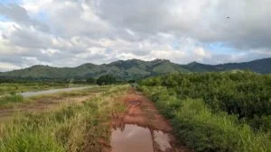 Figure 1. View from a tidal levee showing intact mangroves (right) and low-lying drained farmland (left).
Quantifying the elevation shift
At Raviravi, the surveys revealed significant elevation differences across the levee system. In some areas, we recorded offsets exceeding half a metre, with former farmland now sitting markedly lower than the adjacent intertidal mangrove zone.
This difference in height has practical consequences. When land lies below the tidal platform in front of it, drainage slows and becomes more difficult, particularly during heavy rainfall or high tides. In several locations, exposed salt pans on the landward side of the levee provided visible evidence of ongoing saltwater intrusion and prolonged waterlogging.
Together, these findings demonstrate how physical changes in land elevation directly influence both agricultural viability and restoration potential.
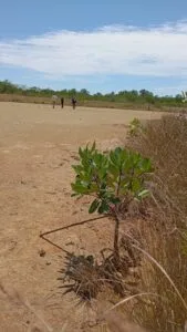 Figure 2. RTK GPS survey underway across subsided farmland. Visible salt pans and small mangrove recruits highlight saltwater intrusion behind the tidal barriers.
Implications for restoration
Mangroves grow within specific elevation ranges along the shoreline. Their survival depends on a balance between tidal flooding and exposure. If land has subsided below this natural range, conventional tidal restoration may not be sufficient.
In areas where the ground now sits too low, prolonged inundation could exceed the tolerance limits of many mangrove species, reducing survival and long-term success.
These findings also highlight the urgency of action. As sea levels continue to rise, low-lying areas behind tidal barriers will become increasingly vulnerable to flooding and saltwater intrusion. Without intervention, elevation deficits are likely to worsen, further limiting both agricultural viability and restoration opportunities.
Future restoration at these sites may therefore require carefully designed solutions, including managed tidal exchange, hydrological redesign, or the selection of mangrove species adapted to lower-elevation conditions.
Building an evidence base for action
This first field campaign provides a critical foundation for adaptive, science-led restoration under Project Halo. Further surveys are now planned to determine the extent of subsidence across additional sites and to support detailed, location-specific restoration design.
By integrating geomorphology, ecology and engineering, Project Halo is ensuring that mangrove restoration reflects the physical realities of altered coastal landscapes, strengthening long-term resilience across Fiji’s coastlines in the face of a changing climate.